The Affordable Housing Landscape in NYC: What Systems Comprise the "Affordable Housing" Network, and Where Are They Located?

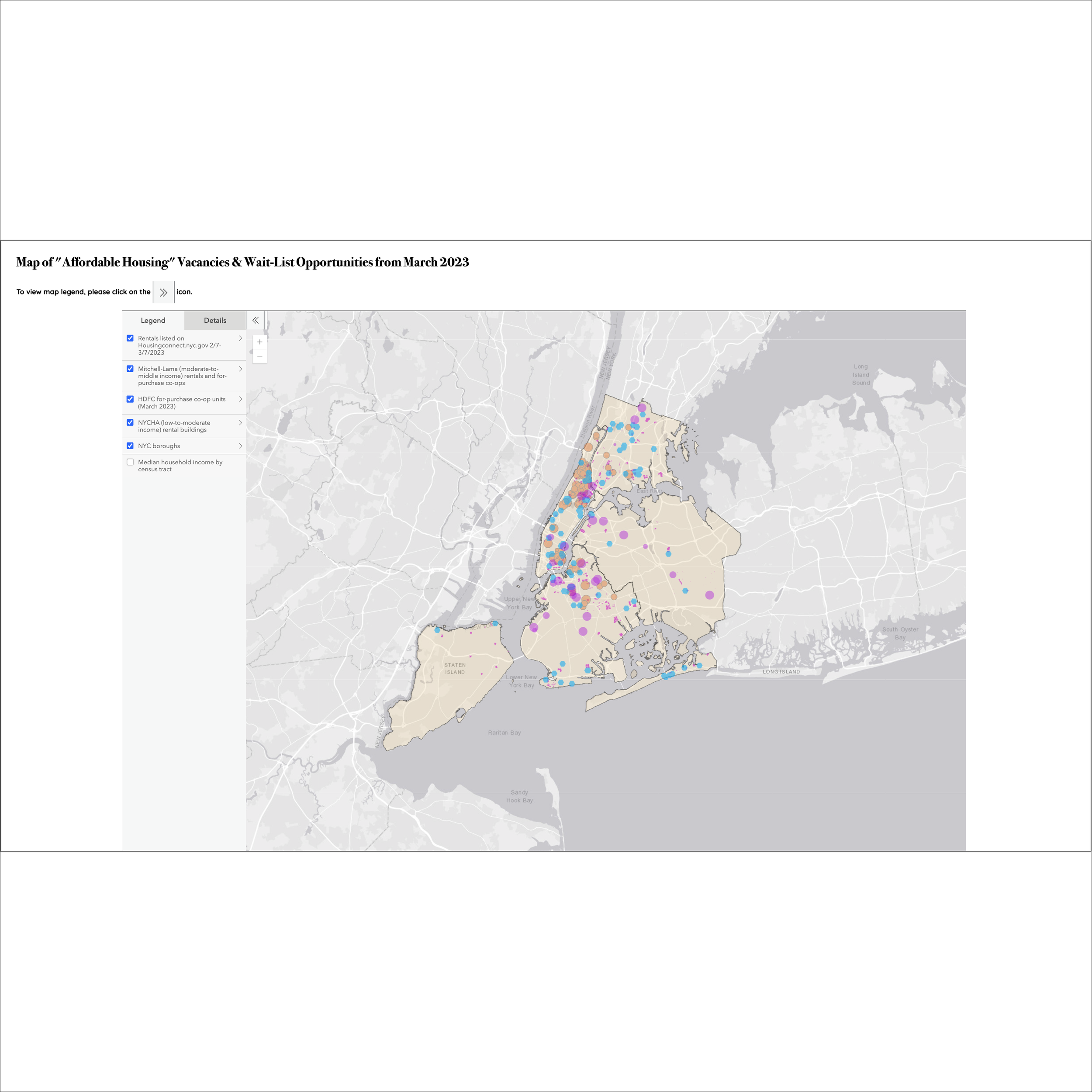
Interactive map of "affordable housing" vacancies and wait-list opportunities for March 2023. (Created in ArcGIS Online.)

In 2021, of the 3,644,000 NYC housing units available, 62% (2,274,200) of them were rentals while 28% (1,016,525) were owner-occupied. (Chart created in Flourish Studio.)
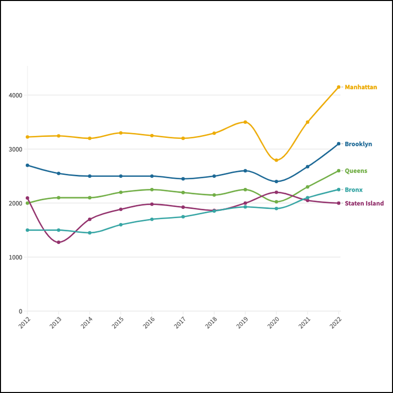
By Dec. 2022, these were the median asking rents for each of the five boroughs according to StreetEasy. (Chart created in Flourish Studio.)
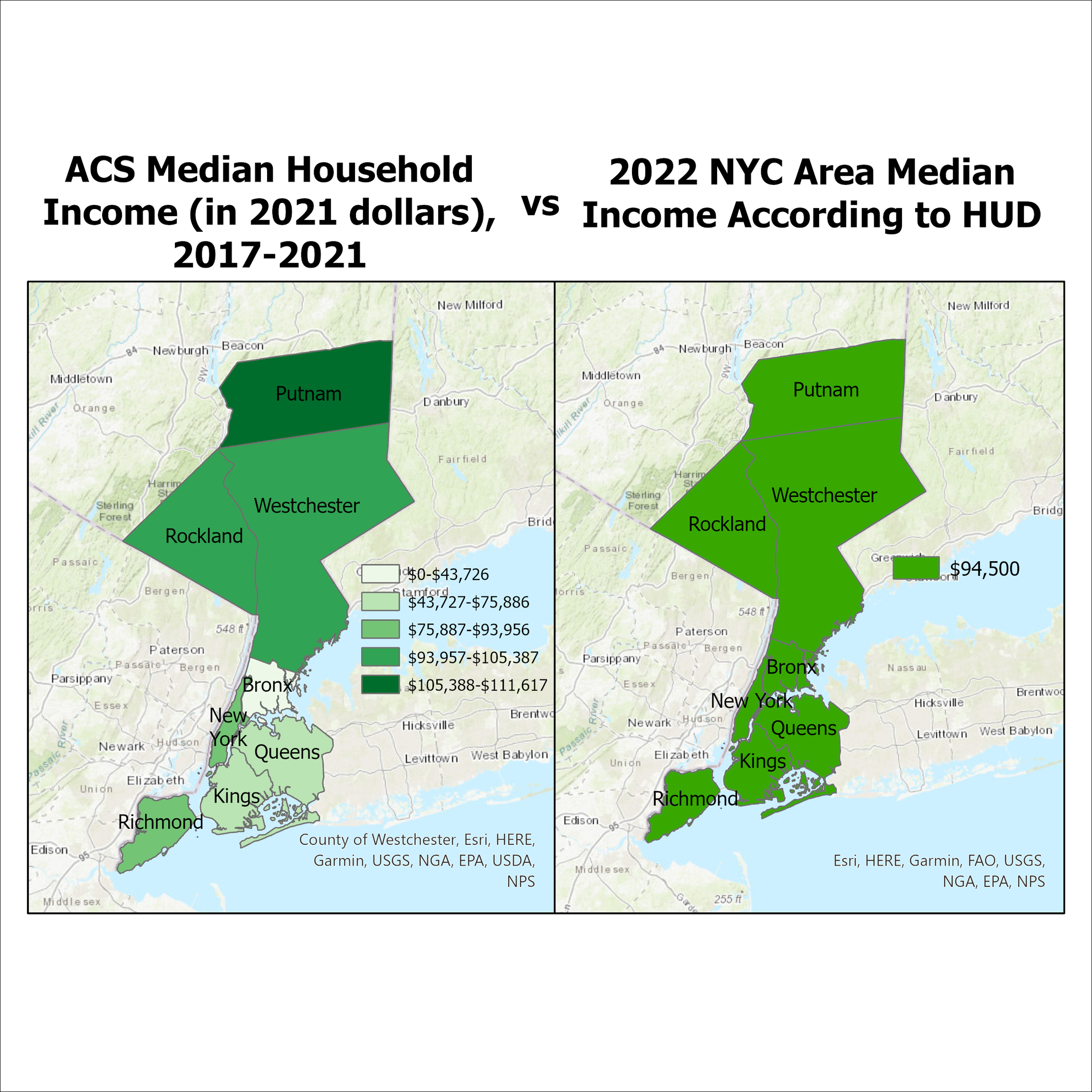
For some reason, HUD includes Putnam, Rockland, and Westchester Counties into its calculation of the NYC Area Median Income. (Graphic created in ArcGIS Pro.)
(The live website is located at nycaffordablehousinglandscape.com.)
Executive Summary
For my final project in Advanced Projects in Visualization, I wanted to understand what options exist concerning “affordable housing” in NYC. I learned that In NYC, “affordable housing” is a complicated hodge-podge of systems that can largely be broken down to:
1) New York City Housing Authority (NYCHA) - Founded in 1934 to try to fix the shoddy tenements during the Great Depression, today NYCHA comprises about 335 buildings in approximately 178,000 apartments, housing around 350,000 residents across the city.
2) The Department of Housing Preservation and Development (HPD) - HPD is responsible for developing and maintaining NYC's stock of affordable housing. The rest can be found under this HPD umbrella:
Mitchell-Lama moderate-to-middle-income rental and for-purchase co-op units: 91 developments with approximately 46,000 units. The Mitchell-Lama program was created in 1955 to provide affordable rental and for-purchase cooperative housing for moderate-to-middle-income families. A full list of the developments can be found here.
Section 8 Housing Choice Voucher Program (Low-income participants pay no more than 40% of their adjusted monthly income, then use housing vouchers to cover the rest): There are ~85,000 vouchers helping house NYC residents across the city
Housing Development Fund Corporation (HDFC) Co-ops: Today, there are over 1100 co-ops. Units that are for sale can be found on Streeteasy.com by going to "More Filters" using the "Income Restricted" filter or on Zillow.com by going to "More Filters" and typing "HDFC" into the "Keywords" search bar. Established in 1966, the purpose of the HDFC program is to provide loans to nonprofit organizations to develop low-income housing projects.
Housing Development Corp. (HDC): Low-to-middle income rentals and co-ops for purchase found via the NYC Housing Development Corp. and NYC Housing Connect websites. Established in 2003, the HDC is a public benefit corporation that finances the creation and preservation of affordable housing in NYC. The year it launched, it originated, committed or completed re-financings totaling $595 million.
Tools Used
Programming languages: Python, R, html, css
Google Maps API (to geocode addresses to longitude, latitude)
ArcGIS Pro, ArcGIS Online (to create maps)
Method
I decided to create a layer for each of these systems except for Section 8. This is because it’s difficult to track which addresses the Section 8 vouchers are being used for since they’re mixed in with market-rate apartments.